
All I knew, what I had learned the previous day from the Jeep rental owner, was that we would be driving along a twenty mile stretch of rough road that would take us up to 12,800 feet and about three and a half hours to traverse. I imagined a few bumpy hours. I thought the major challenge of the day - the climb - was behind me. What I knew, imagined, thought were nothing like what I was about to experience.
The Climb to Engineer's Pass
As we headed east along the first few miles from Nellie Creek, the road was gravel but (relatively) smooth; the midday sun was bright overhead. We were slowly climbing up a valley parallel to the swiftly flowing Henson Creek; steep, timbered ridges rising on either side of us. The water was surging downhill (the way we should have been going).
I'm an engineer and I design roads for a living. I asked my uncle why this pass was called "Engineer's Pass", I thought maybe there was a good story behind it. He didn't know. I made a mental note to research it after we were got back.
We passed a sign that read "End of Road Maintenance". With a bump, bang, and shudder we were in four-wheel drive territory. The signs should have read "End of Road - PROCEED AT YOUR OWN RISK!!". Our progress slowed substantially, the road turned noticeably more upward. I asked my aunt for the rudimentary map of these four-wheel drive mountain trails that came with the Jeep. I tried to read the map as we bounced all over the place and my hands, head, and eyes, jerked in different directions. We had about eight miles until Engineer's Pass and then about the same distance back down to an actual road.
Slowly, jerkily we crawled higher, above the trees into the alpine tundra. A string of vehicles were stretched out along the road, most headed in the opposite direction. It looked like a bad version of the Burma Road. At one point we saw a sign that must have been a joke, "Four Wheel Drive Vehicles Recommended Beyond This Point." I was too uncomfortable to appreciate the humor. I was already a little queasy from the earlier climb. The last thing I wanted to be doing was rising back into thin air. It got cold. Finally, a long hour after we had started we reached Engineer's Pass. The changeable weather had turned gray and it was starting to drizzle. I didn't see a pass at all, we basically had driven to the top of the 13,000 foot Engineer Mountain! (An explanation for the name; by then I wasn't interested.)
The Descent
Okay, we made it to the pass. I couldn't care less about the soaring views of mountains, valleys, and sky. I had enough of that on top of Uncompahgre, I just wanted to head down. I needed thicker air and warmer temperatures. We moved on. And that's when it got scary.
Immediately there was an unexpected decision, we could turn right or head straight. No signs indicated the correct direction. Neither option looked appealing. My uncle chose straight. I looked at the map and thought right, but said nothing.
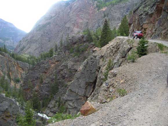
 |
| The "road" down from Engineer's Pass |
 |
| The valley far below |
 We faced another choice. Go back over the terrible track we had just gone down and back up. Or back over Engineer's Pass, and the long miserable ride down to Lake City. In a journey of bad decisions we made another one, choosing the devil we didn't know, back where we had just been...the terrible path along the cliff (for a third time). Slowly, unsteadily we descended. We reached the first switchback, then the next. A white pick-up and a few ATVs passed us going the other way. Thankfully there was room. We eventually reached the valley floor. I looked back up the towering mountainside. I could see the white pick-up climbing far above us. I felt sorry for the occupants. I shuddered thinking we had just driven along that rocky wall (three times!).
We re-entered the tree line and followed the valley down above Mineral Creek. I thought the worst was over, but the road wasn't any better. If anything it was getting worse. We weren't driving, we were rock crawling. Nothing but exposed rocks - big rocks - and deep ruts. There was a handle bar built into the dashboard in front of the passenger seat, I griped it like a man on a wild carnival ride. I was as attentive and tried to anticipate the endless small maneuvers that my uncle was forced to make.
The rain, which had been intermittent, picked up to a heavy downpour. The map said we still had five miles to go. That seemed an eternity. We passed a couple of trucks. We stopped to confirm that we were in fact heading towards Ouray (the trust in our own navigation was left on top of Engineer Mountain). The driver said yes. He asked if his group was headed to Engineer's Pass. We said yes and wished him good luck. His words, "so the road doesn't get any better?" We said no, we were right and wrong.
 |
| "Recommended" - a colossal understatement |
I still felt sick. I was sapped, drained. We made it off a "road" none of us will ever take again. I thanked my uncle for getting us out without incident - a deserved thanks if there ever was one.
---
I had a mind to call to Colorado Department of Transportation and complain. I design roads for a living and that was not a road. But later, while we recovered with a short rest in Ouray a local told us that a lot of people enjoy that type of road. Maybe, there's plenty of wanna-be Travis Pastrana's out there, and life is dangerous (see this article about another similar nearby road). Four-wheeling like that is not my type of fun and is one danger that I won't subject myself to ever again.
I was happy to let my fatigue take over and let the whole experience fade out. It had been a long day.
I just got such a laugh out of this! Several years ago I met a friend in Denver and we headed out with her daughter four Ouray area. We stayed in a place called the Texan in Lake City. Now, we are two girls with a kid and none of us are the brave type at all. The guy who runs the Texan said that Engineer pass was a short cut to Ouray.....yes, he said that. Oh, ya he did add that it was a 8 to 10 mile scenic drive. So off we went in my friends 4 wheel drive Ford Explorer for the scenic drive. Ya, well it was scenic for about 30 minutes and the rest was sheer torture. When we finally made it to the sign at the top..after making a 12 point turn to get around a switchback, we were terrified. Now we pass the sign and head up when there in the middle of the road is a huge "puddle". Now, by puddle I mean is it 6" deep or 10" deep? We could not turn around and our only choice was to go through it. Our hearts were racing, I was crying and so was the child. The driver, my friend was telling us to shut the heck up (not so politely)because she was on her last nerve. Now, we get to the same spot you did. THE FORK IN THE ROAD on the top of the damn mountain. NO sign, we chose to go to the "left" or around the mountain. Now we are headed straight down to Hell as far as we were concerned. Harrowing does not describe the downhill....worse (if possible) than uphill. We ended up in Silverton, not Ouray and went directly to the nearest bar and ordered shots of vodka. We told the bartender we had just come over the pass and he'slooking around and goes..so where are the men who drove you over? I can only point at my friend and he was holy crap, I took my wife over once and she wanted to kill me. Anyway it now gives us a good laugh. So funny that you told the exact story. Thanks! Mary
ReplyDeleteMary,
ReplyDeleteI'm glad to hear that someone else felt as desperate as we did in taking this "road". I'm also glad to hear that you made it down safe. I would have had a shot of liquor myself after getting back to Ouray, except my stomach was still doing somersaults.
Don't you love the attitude of the locals, "the roads no big deal, no problem." Unnecessary nonchalance, and unfair when it gives a wildly understated perspective to people like us.
Thanks for your comment and please keep reading.